
The geography of Bulgaria combines mountains, plains, rivers, and a Black Sea coastline, making it one of the most geographically diverse countries in Southeastern Europe. This varied landscape shapes the country’s climate, ecosystems, agriculture, and travel experiences across different regions.
What makes the geography of Bulgaria especially distinctive is how these natural features are interconnected. Mountain ranges influence river systems, plains support agriculture, and coastal areas drive tourism, creating a balanced and dynamic environment.
From the fertile Danubian Plain in the north to the rugged peaks of the Rila and Pirin Mountains, and from the forested Rhodopes to the Black Sea coast, Bulgaria brings together a wide range of landscapes within a relatively small territory. Each region offers its own climate, terrain, and cultural identity.
Understanding the geography of Bulgaria means understanding how its land shapes everything—from history and traditions to food, economy, and modern development. Whether exploring mountains, plains, or coastal areas, geography remains the foundation of Bulgaria’s identity.
Geography of Bulgaria Regions Overview
👉 Here’s a quick breakdown of Bulgaria’s main geographic regions and what they are best known for:
| Region | Landscape | Best For |
|---|---|---|
| Danubian Plain | Flat farmland, river valleys | Agriculture, wine, rural travel |
| Balkan Mountains | Long mountain ridge | Hiking, history, scenic routes |
| Thracian Plain | Fertile lowland | Cities, agriculture, culture |
| Rila & Pirin Mountains | Alpine peaks, lakes | Hiking, skiing, adventure |
| Rhodope Mountains | Forested hills, villages | Culture, folklore, eco tourism |
| Black Sea Coast | Beaches, coastal cities | Summer travel, resorts |
👉 In this guide, you’ll explore Bulgaria by its landforms, regions, climate, and travel experiences—giving you a complete picture of how geography defines the country.
What Is the Geography of Bulgaria?
The geography of Bulgaria includes mountains, plains, rivers, and a Black Sea coastline, creating a highly diverse landscape within a relatively small area. Located in Southeastern Europe, Bulgaria’s geography influences its climate, ecosystems, agriculture, and regional development.
Geography of Bulgaria: Location and Borders
The geography of Bulgaria begins with its strategic location in Southeastern Europe, on the eastern part of the Balkan Peninsula. Positioned between Europe and Asia, Bulgaria has historically served as a crossroads of civilizations, trade routes, and cultural exchange.
Bulgaria shares land borders with five countries:
- To the north: Romania, largely separated by the Danube River
- To the west: Serbia and North Macedonia
- To the south: Greece and Turkey
- To the east: the Black Sea
The country’s total land border stretches approximately 1,800 kilometers, while its eastern coastline along the Black Sea extends about 354 kilometers. This coastal access has played a key role in Bulgaria’s economic development, tourism industry, and maritime connections.
Geographically, Bulgaria sits at a natural intersection of major European regions—Central Europe, Eastern Europe, and the Mediterranean. This position has influenced not only its political history but also its climate, biodiversity, and cultural diversity.
👉 Bulgaria’s location has shaped its identity for centuries—explore this further in → Bulgarian History Overview.
Bulgaria’s geography is best understood not as separate regions, but as a connected system where mountains, plains, rivers, and coastlines interact to shape climate, culture, and daily life. The Balkan Mountains divide north and south, rivers carve natural corridors across the land, and the Black Sea opens the country to global trade and tourism. As you move through each region below, you’ll see how these geographic elements are not isolated—they work together to form a diverse and balanced landscape that defines Bulgaria as a whole.
Physical Geography Overview

The physical geography of Bulgaria is shaped by a compact but highly structured landscape that includes plains, mountain ranges, valleys, and a coastal zone. These landforms create distinct geographic regions with clear differences in terrain, climate, and land use.
Four major regions define the country’s physical structure:
- Danubian Plain (north) — a fertile lowland dominated by agriculture
- Balkan Mountains (Stara Planina) — a central mountain chain dividing northern and southern Bulgaria
- Thracian Plain (south) — a warm and productive agricultural region
- Rila–Rhodope Massif (southwest) — a mountainous area containing Bulgaria’s highest peaks
The Balkan Mountains stretch across the country from west to east, forming a natural divide that separates the flatter northern plains from the more varied southern terrain. This division also influences regional climate patterns and land use.
In southwestern Bulgaria, the Rila, Pirin, and Rhodope Mountains create a more rugged landscape characterized by high elevations, deep valleys, and forested areas. These regions contain the country’s most prominent peaks and natural features.
Toward the east, the terrain gradually transitions into the Black Sea coast, where lowlands, cliffs, and sandy beaches introduce a distinct coastal environment.
Overall, plains occupy roughly one-third of Bulgaria’s territory, while hills and mountains make up the majority. This distribution of landforms plays a central role in shaping agriculture, settlement patterns, and natural ecosystems across the country.
👉 This geographic diversity is closely linked to Bulgaria’s natural resources and scientific development → Bulgarian Science and Technology History.
Geography of Bulgaria: Major Landforms
The geography of Bulgaria is defined by the interaction between plains, mountain ranges, and transitional zones that shape the country’s terrain and regional structure.
Rather than repeating the main regions, this section focuses on how these landforms connect and create a layered landscape across Bulgaria.
The Balkan Mountains stretch across the country from west to east, forming a natural boundary between northern and southern Bulgaria. To the north, the terrain remains largely flat, while to the south it gradually transitions into lower plains and then rises again into mountainous areas.
In southwestern Bulgaria, the terrain becomes more complex, with the Rila, Pirin, and Rhodope Mountains introducing higher elevations, deep valleys, and varied terrain. These differences in elevation and structure define how land is used across regions.
This combination of flat and elevated terrain creates a balanced geographic system that supports agriculture in lowlands and concentrates natural features in mountainous regions.
👉 These landforms also directly influence regional food production and traditions → Bulgarian Cuisine: Complete Food Guide.
Danubian Plain Bulgaria: Northern Agricultural Heart
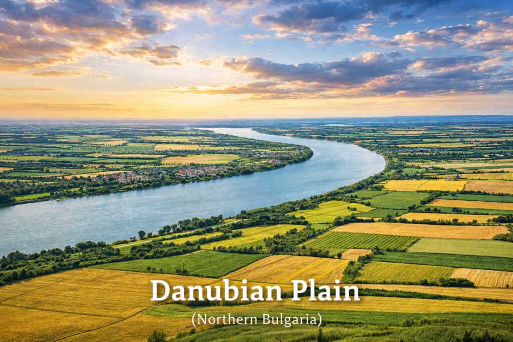
Following the broader structure of Bulgaria’s landforms, the Danubian Plain represents the country’s largest lowland region, stretching across northern Bulgaria along the Danube River, which forms the natural border with Romania.
Key Characteristics
- Predominantly flat to gently rolling terrain
- Fertile soils suitable for large-scale agriculture
- Extensive cultivation of wheat, corn, sunflower, and barley
- Interspersed with plateaus, valleys, and low hills
This region plays a central role in Bulgaria’s agricultural output and food supply. Its fertile land supports the cultivation of wheat, corn, barley, and other staple crops, making it one of the country’s most productive farming zones.
Geographic Structure
The Danubian Plain gradually rises from the Danube River toward the foothills of the Balkan Mountains, creating a natural transition between lowland and upland terrain.
- Near the Danube → flatter, more humid landscapes
- Toward the south → slightly elevated and more varied terrain
This gradual shift influences both land use and settlement patterns across the region.
Climate and Agriculture
The Danubian Plain experiences a continental climate, with:
- Hot summers
- Cold winters
- Moderate rainfall
These conditions are well-suited for agriculture but can also bring seasonal extremes such as droughts or heavy snowfall.
👉 Many traditional foods and rural lifestyles originate from these fertile lands → Traditional Bulgarian Breakfast Foods.
The Danubian Plain Regional Role
The Danubian Plain is the core of Bulgaria’s grain production, where large-scale farming dominates the landscape. Its position along the Danube has also made it a long-standing corridor for transport, trade, and cultural exchange.
As the terrain rises southward, the landscape shifts dramatically into the mountainous spine of the country—the Balkan Mountains.
Balkan Mountains (Stara Planina): The Natural Divide
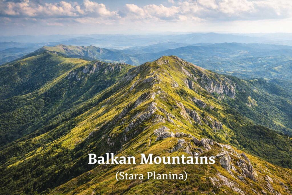
The geography of Bulgaria is continuing south from the Danubian Plain, as the terrain rises into the Balkan Mountains (Stara Planina), a continuous range that stretches from western Serbia to the Black Sea.
Key Characteristics
- Run west to east across the entire country
- Act as a natural divider between northern and southern Bulgaria
- Feature a mix of forested slopes, rocky ridges, and high passes
- Include important routes such as the historic Shipka Pass
Geographic Role
The Balkan Mountains act as a structural divide within Bulgaria’s landscape, separating the flat northern plains from the more varied southern regions. This division influences movement, settlement, and regional development.
Climatic Influence
The range also functions as a climatic boundary:
- North of the mountains → stronger continental conditions
- South of the mountains → increasing Mediterranean influence
This contrast creates noticeable differences in temperature, precipitation, and seasonal patterns across relatively short distances.
Historical Importance
Throughout history, the Balkan Mountains served as a natural defensive barrier and a refuge during periods of conflict. Their terrain influenced settlement patterns and played a role in key historical events.
👉 These natural barriers shaped major historical developments → Bulgarian National Revival
Transition to Southern Bulgaria
As the land descends south of the Balkan Mountains, the terrain opens into a broad lowland region known as the Thracian Plain.
Thracian Plain Bulgaria: Southern Fertile Region
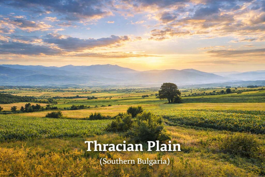
The Thracian Plain forms the main lowland of southern Bulgaria and one of the most productive and historically significant regions in the geography of Bulgaria. Located south of the Balkan Mountains, it centered around the valley of the Maritsa River and extending eastward toward the Black Sea.
Key Characteristics
- Broad, low-lying plain
- Fertile soils suitable for intensive agriculture
- One of the country’s main agricultural regions
- Includes major urban centers such as Plovdiv
Landscape and Climate
The Thracian Plain benefits from warmer conditions compared to northern Bulgaria:
- Milder winters
- Hot, dry summers
- Longer growing season
These conditions support a wider range of crops, including fruits, vegetables, and vineyards.omy.
Regional Role
This region is a major center of agricultural production in southern Bulgaria, complementing the grain-producing areas of the north with more diverse farming.
👉 This fertile region continues to influence Bulgaria’s culinary traditions → Bulgarian Salads: Famous Recipes and Ingredients.
Together, the Balkan Mountains and the Thracian Plain highlight how the geography of Bulgaria creates natural divisions while also supporting diverse lifestyles, economies, and cultural traditions across the country.
Further southwest, the terrain rises again into Bulgaria’s highest and most rugged mountain systems.
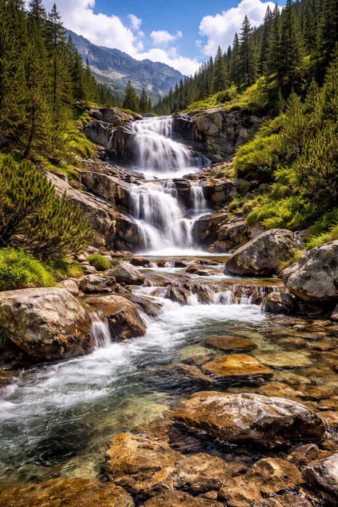
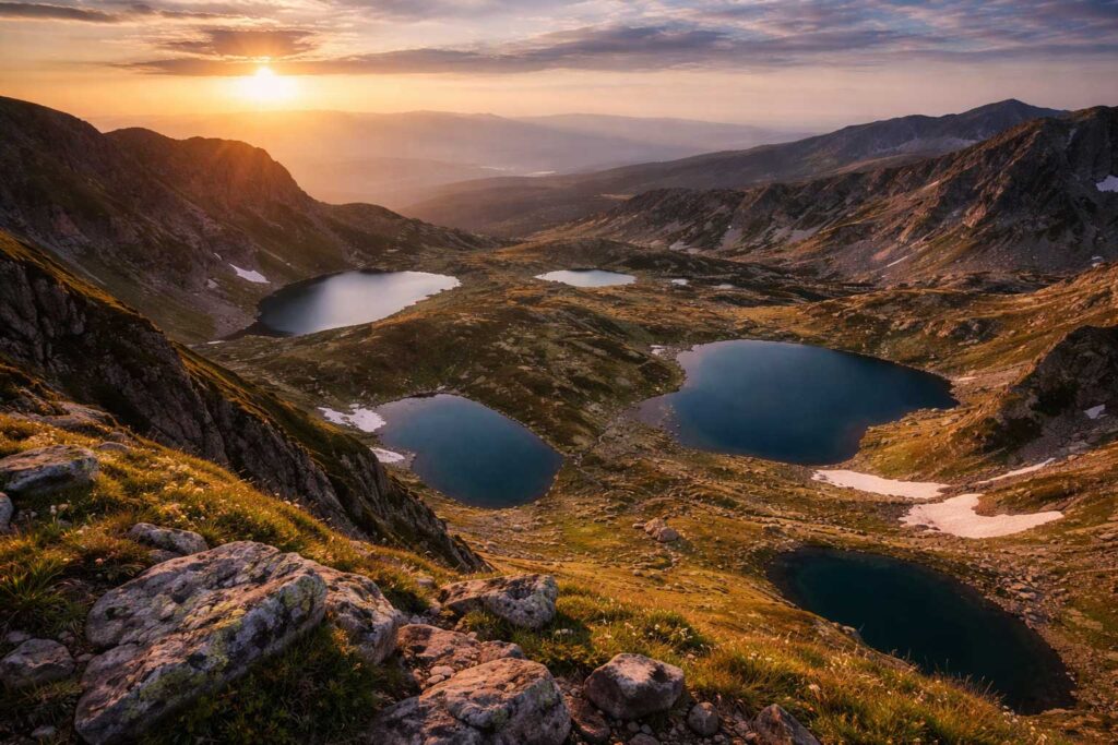
Rila Mountains Bulgaria: The Roof of the Balkans
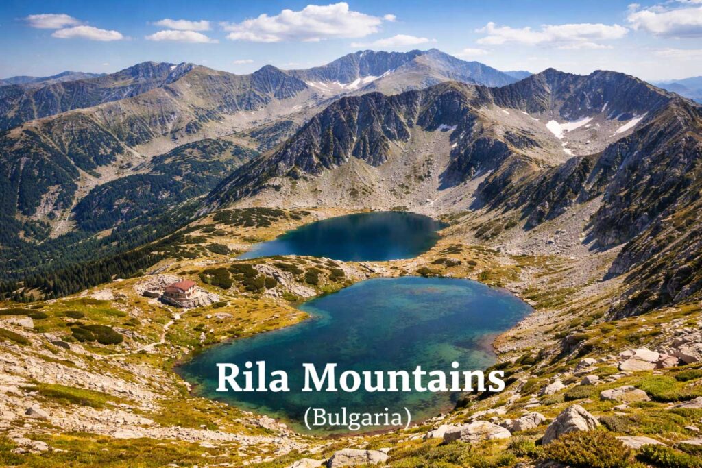
Rising in southwestern Bulgaria, the Rila Mountains form the highest mountain range in the country and the entire Balkan Peninsula. Their elevation and alpine character make them one of the most prominent features in the geography of Bulgaria.
Key Characteristics
- Home to Musala (2,925 m) — the highest peak in the Balkans
- Alpine terrain with sharp ridges, cirques, and glacial valleys
- Over 200 glacial lakes, including the Seven Rila Lakes
- Extensive coniferous forests at lower elevations
Musala Peak
At the center of the range stands Musala, the highest point in Bulgaria and Southeast Europe.
- Elevation: 2,925 meters (9,596 ft)
- Dominant summit in the Balkan Peninsula
- Offers wide panoramic views across surrounding regions
👉 Want to explore Bulgaria’s highest peaks and glacial lakes? See the full guide → Rila Mountains Travel Guide.
The Seven Rila Lakes
The Seven Rila Lakes are among the most recognizable natural landmarks in Bulgaria, formed during the last Ice Age and arranged in a cascading formation at high elevation.
- Located in a high mountain cirque.
- Glacial origin
- Distinct shapes and names
Climate and Ecosystems
The Rila Mountains experience a mountain (alpine) climate:
- Long, snowy winters
- Cool summers
- High precipitation levels
These conditions support:
- Coniferous forests
- Alpine meadows
- Diverse plant and animal species
👉 Bulgaria’s natural ecosystems are closely connected to its biodiversity and traditions → Bulgarian Yogurt: History and Health Benefits.
Cultural Significance
Rila is also home to the renowned Rila Monastery, one of the most important cultural and spiritual landmarks in Bulgaria, located deep within the mountain landscape.
Geographic Role
The Rila Mountains represent the highest elevation zone in Bulgaria and serve as a major source of rivers and freshwater. Their terrain contrasts sharply with the surrounding plains, highlighting the vertical diversity of the country’s landscape.
To the south of Rila, the landscape continues into another high mountain range with equally rugged terrain—the Pirin Mountains.
Pirin Mountains Bulgaria: Alpine Landscapes and UNESCO Heritage
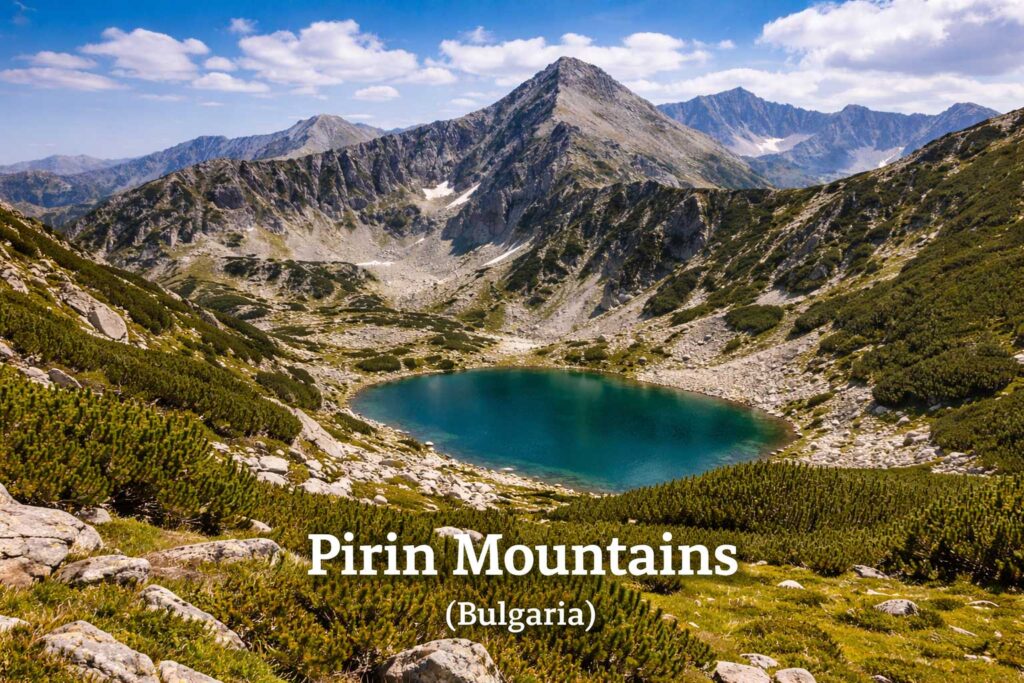
Located just south of the Rila Mountains, the Pirin Mountains form one of the most rugged and sharply defined mountain ranges in the geography of Bulgaria. Their steep relief and high elevations give them a distinctly alpine character.
Key Characteristics
- Sharp, jagged peaks and narrow ridges
- Over 170 glacial lakes
- Compact but highly elevated terrain
- Distinct marble formations, especially around Vihren (2,914 m)
Vihren Peak is the second-highest summit in Bulgaria and a defining feature of the range, known for its steep slopes and striking appearance.
Pirin National Park (UNESCO World Heritage Site)
A large portion of the range is protected within Pirin National Park, a UNESCO World Heritage Site recognized for its preserved landscapes and ecological value.
- Glacial landforms shaped during the Ice Age
- Ancient forests, including long-living pine species
- High concentration of endemic plants
👉 Discover alpine trails and protected landscapes → Pirin Mountains Travel Guide.
Landscape Structure
The terrain of Pirin is shaped by glacial processes, resulting in:
- Deep cirques and valleys
- High-altitude lakes
- Steep rocky slopes
Compared to the broader relief of Rila, Pirin is more compact and sharply contoured, creating a more rugged mountain profile.
Climate and Ecosystems
Pirin experiences a mountain (alpine) climate:
- Cold winters with heavy snowfall
- Cool summers
- Rapid weather changes at higher elevations
These conditions support specialized plant species and ecosystems adapted to high-altitude environments.
👉 Mountain ecosystems like these contribute to Bulgaria’s natural diversity → Lactobacillus Bulgaricus Explained.
Regional Role
The Pirin Mountains represent one of the most structurally distinct high-mountain areas in Bulgaria, complementing the broader elevations of Rila and the lower, forested terrain of the Rhodopes.mountainous identity of southern Bulgaria—demonstrating the country’s incredible natural diversity and environmental significance.
To the east and south, the terrain transitions into a different type of mountainous landscape—the Rhodope Mountains.
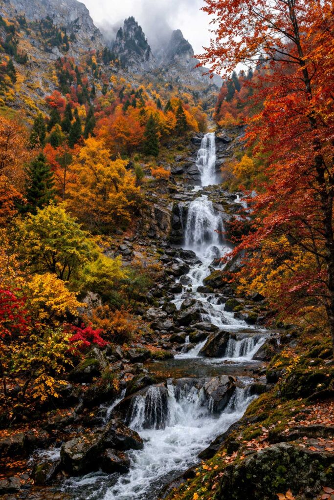
Rhodope Mountains Culture: Folklore, Myth, and Nature
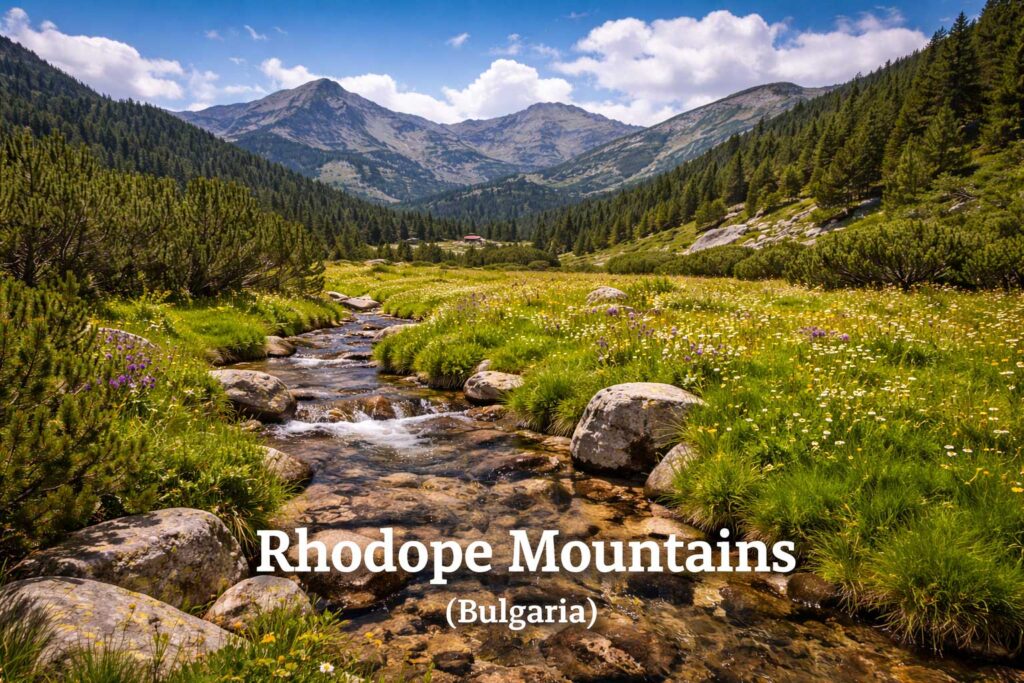
Extending across southern Bulgaria and into northern Greece, the Rhodope Mountains form a distinct type of landscape within the geography of Bulgaria. Unlike the high alpine relief of Rila and Pirin, the Rhodopes are characterized by rounded hills, dense forests, and deeply cut valleys.
Key Characteristics
- Rolling mountain terrain with extensive forest cover
- Deep gorges and cave systems
- Broad valleys and dispersed settlements
- Long-established rural communities
This softer terrain creates a more expansive and accessible mountain environment.
Myth and Folklore
The Rhodopes are closely associated with the legend of Orpheus, the mythical figure said to have lived in this region. This connection has shaped the cultural identity of the mountains for centuries.
The region is known for:
- Traditional folk music
- The kaba gaida (regional bagpipe)
- Oral storytelling traditions
These elements remain an active part of local culture rather than purely historical traditions.
Natural Landmarks
The Rhodope Mountains include some of Bulgaria’s most distinctive natural features:
- Trigrad Gorge — steep canyon landscape
- Yagodina Cave — one of the longest and most beautiful caves in Bulgaria
- Devil’s Throat Cave — a legendary cave associated with myths
These formations reflect the geological diversity of the region.
Climate and Environment
The Rhodopes experience a milder mountain climate compared to higher ranges:
- Cooler summers
- Moderate winters
- Higher humidity levels
These conditions support dense forest ecosystems and a stable natural environment.
👉 These environments contribute to Bulgaria’s broader ecological diversity → Bulgarian Natural Wonders.
Cultural Landscape
The Rhodopes are notable for the continuity of traditional rural life:
- Stone-built mountain villages
- Local crafts and small-scale agriculture
- Long-standing cultural practices
Many settlements remain closely connected to the surrounding landscape.
👉 Discover more about rural traditions → Bulgarian Villages and Rural Culture.
Geographic Role
The Rhodope Mountains provide a contrast to Bulgaria’s higher alpine regions, adding a forested and culturally distinct dimension to the country’s southern terrain.
👉 Experience traditional villages and folklore → Rhodope Region Travel Guide.
While mountains define Bulgaria’s elevation and climate, its rivers bring life to these landscapes—connecting regions and supporting ecosystems across the country.
Rivers in Bulgaria: Major Water Systems and Geography
Following the mountainous structure of the country, Bulgaria’s rivers form a network that connects high elevations with plains and coastal regions. These water systems play a central role in shaping valleys, supporting agriculture, and influencing settlement patterns.
Major River Basins
Bulgaria’s rivers are divided into two primary drainage systems:
Black Sea Basin
- Covers most of northern and eastern Bulgaria
- Includes rivers such as the Kamchiya and Provadiya
- Drains directly into the Black Sea
Aegean Sea Basin
- Covers southern and southwestern regions
- Includes the Maritsa River and Struma River
- Flows through neighboring countries before reaching the Aegean Sea
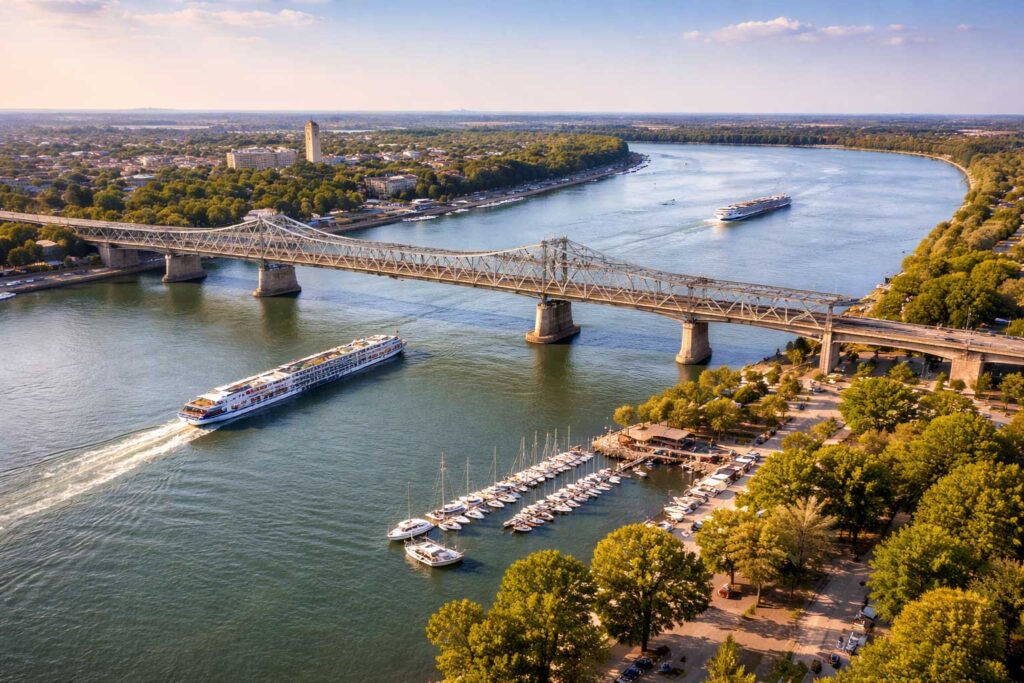
The Danube River
The Danube River forms most of Bulgaria’s northern border with Romania and is the largest river connected to the country.
- Defines the northern boundary of the Danubian Plainor.
- One of Europe’s major waterways
- Key route for transport and trade
Major Rivers Within Bulgaria
Iskar River
- Longest river entirely within Bulgaria (≈368 km)
- Originates in the Rila Mountains
- Flows north through the Balkan Mountains via the Iskar Gorge
Maritsa River
- Main river of southern Bulgaria
- Flows across the Thracian Plain
- Continues into Greece and Turkey
Struma River
- Important for regional water systemst flows entirely within Bulgaria.
- Flows through southwestern Bulgaria
- Originates near Sofia and continues south into Greece
Seasonal Patterns
River flow in Bulgaria varies throughout the year:
- Higher levels during spring snowmelt
- Lower levels in summer
- Occasional flooding in certain regions
These seasonal changes reflect the country’s climate and mountainous terrain.
Geographic Role
Rivers in Bulgaria act as natural connectors between mountains, plains, and coastal areas. They shape valleys, influence land use, and support agricultural regions such as the Danubian and Thracian plains.
👉 Rivers have long supported traditional agriculture and food systems → Bulgarian Agriculture and Food Traditions.
From the powerful Danube to the flowing valleys of the Maritsa and Struma, Bulgaria’s rivers are not just natural features—they are lifelines that sustain the country’s landscapes, economy, and way of life.
As these rivers move eastward, they connect Bulgaria’s interior landscapes with its Black Sea coastline.
The Danube River and Northern Border
Flowing along northern Bulgaria, the Danube River forms most of the country’s border with Romania. As one of Europe’s longest rivers, it defines the northern edge of Bulgaria and shapes the surrounding lowland landscape.
Geographic Role
- Forms a natural boundary between Bulgaria and Romania
- Flows west to east toward the Black Sea
- Influences the terrain of the Danubian Plain
Many settlements developed along its banks, reflecting its long-term role in regional development.
Economic Corridor
The Danube functions as a major transport route connecting Bulgaria to Central and Western Europe.
- Connects Bulgarian cities such as Ruse and Vidinope.
- Supports shipping and trade networks
- Links inland regions to the Black Sea
Environmental System
The river also supports important natural habitats:
- Wetlands and floodplain ecosystems
- Bird migration routes
- Freshwater biodiversity
Protected areas along the Danube help preserve these ecosystems.
Historical Context
Throughout history, the Danube has functioned both as a frontier and a connection point, influencing trade routes, migration, and cultural exchange across the region..
👉 The Danube has shaped Bulgaria’s economic and historical development → Bulgarian Economic History.
Geographic Significance
The Danube River defines Bulgaria’s northern boundary while linking the country to wider European systems. Its role as a natural border, transport corridor, and ecological zone makes it one of the most influential geographic features in Bulgaria.in Europe.
Beyond the river systems, Bulgaria’s geography continues eastward toward its coastal landscape along the Black Sea.
Major Rivers: Iskar, Maritsa, and Struma
Beyond the Danube River, Bulgaria’s internal river network is shaped by three major systems: the Iskar, Maritsa, and Struma rivers. Each flows through a different part of the country, linking mountain regions with plains and neighboring territories.
Iskar River
The Iskar River is the longest river entirely within Bulgaria.
- Length: approximately 368 km
- Originates in the Rila Mountains
- Flows northward through the Balkan Mountains
- Empties into the Danube
One of its defining features is the Iskar Gorge, where the river cuts through mountainous terrain, creating a major natural passage.
Maritsa River
The Maritsa River is the most important river in southern Bulgaria and one of the largest in the Balkan Peninsula.
The Maritsa River is the main river of southern Bulgaria.
- Flows across the Thracian Plain
- Passes near Plovdiv
- Continues into Greece and Turkey
Its wide valley supports intensive agriculture and defines much of southern Bulgaria’s lowland landscape.yards.
Struma River
The Struma River flows through southwestern Bulgaria toward the Aegean region.
- Originates in western Bulgaria
- Passes through the Kresna Gorge
- Continues south into Greece
The river valley forms a natural corridor connecting inland Bulgaria with southern regions.
Geographic Role
Together, these rivers connect Bulgaria’s mountain sources with its plains and neighboring regions. Their courses shape valleys, influence land use, and support agricultural areas across the country.ects the landscape it flows through—from mountain origins to lowland plains—demonstrating the diversity of Bulgaria’s geography.
As these rivers flow eastward, they ultimately connect to Bulgaria’s coastal identity, where land meets the Black Sea.
👉 Rivers like these have shaped traditional agriculture and regional life → Bulgarian Agriculture and Food Traditions.
Affiliate Disclosure: This article may contain affiliate links. If you purchase through these links, we may earn a small commission at no extra cost to you.
Beach & Summer Travel Essentials
| Product | Best For | Why It’s Useful | Check Price |
|---|---|---|---|
| UV Protection Sunglasses | Coastal travel | Strong summer sun | 👉 Check Price on Amazon |
| Beach Towel (Quick Dry) | Resorts | Lightweight + fast drying | 👉 Check Price on Amazon |
| Sunscreen SPF 50+ | All travelers | Essential for Black Sea coast | 👉 Check Price on Amazon |
| Waterproof Phone Case | Beach days | Protects from water and sand | 👉 Check Price on Amazon |
| Travel Cooler Bag | Road trips | Keeps drinks and food fresh | 👉 Check Price on Amazon |
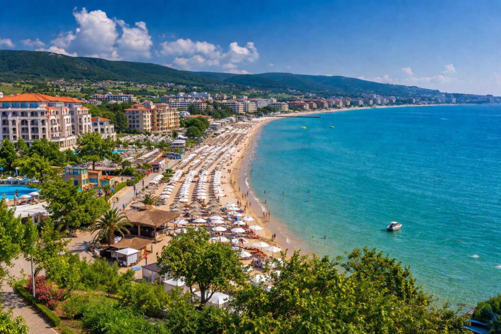
Black Sea Coast: Bulgaria’s Eastern Gateway
As Bulgaria’s rivers flow eastward, the landscape opens into the Black Sea, forming a 354-kilometer coastline that defines the country’s eastern boundary.
Geographic Characteristics
- Mix of sandy beaches, rocky cliffs, and coastal bays
- Coastal lakes, wetlands, and river estuaries
- Generally low tidal range, resulting in calm sea conditions
These features create a distinct coastal environment compared to inland regions.
Major Coastal Cities
The coastline is anchored by two main urban centers:
- Varna — a major port and cultural center
- Burgas — a southern hub for transport and industry
Both cities serve as key points for trade, regional connectivity, and coastal development.
Coastal Landscape and Climate
The Black Sea coast experiences a maritime-influenced climate:
- Warm summers
- Mild winters
- Sea breezes that moderate temperatures
This creates conditions that differ from Bulgaria’s inland continental climate.
Natural Systems
The coastline supports important ecosystems:
- Wetlands and lagoons along the shore
- Bird migration routes of European significance
- Marine habitats with diverse species
Protected zones help maintain these environments.
Geographic Role
The Black Sea coast connects Bulgaria to international maritime routes while adding a coastal dimension to its otherwise land-dominated geography. It contrasts with the country’s mountainous and inland regions, completing the full range of landscapes found within Bulgaria.
This variation in terrain directly influences Bulgaria’s climate, creating distinct weather patterns across different regions.
👉 Planning a summer trip? See → Black Sea Resorts: Beaches, Cities, and Coastal Culture.
👉 Coastal regions also influence local cuisine → Bulgarian Seafood and Coastal Dishes.
Bulgarian Climate Zones: Continental, Mediterranean, and Mountain Influences
Following the variation in terrain across the country, the geography of Bulgaria creates distinct climate zones shaped by elevation, latitude, and proximity to the Black Sea.
Main Climate Zones
Bulgaria’s climate can be divided into three primary zones:
Continental Climate (Northern Bulgaria)
- Dominates the Danubian Plain and northern regions
- Characterized by:
- Hot summers
- Cold winters
- Larger temperature differences between seasons
This is the most typical climate in Bulgaria and strongly influences agricultural cycles.
Mediterranean Influence (Southern Bulgaria)
- Affects the Thracian Plain and southern valleys
- Characterized by:
- Milder winters
- Hot, dry summers
- Longer growing seasons
This influence becomes stronger toward the south and southwest of the country.
Mountain Climate (High Elevations)
- Found in the Rila Mountains, Pirin Mountains, and Rhodope Mountains
- Characterized by:
- Cooler temperatures
- Heavy snowfall in winter
- Rapid weather changes
Higher elevations create localized weather patterns that differ significantly from surrounding lowlands.
Coastal Climate Influence
Along the Black Sea coast, the presence of the sea moderates temperature extremes:
- Warmer winters compared to inland areas
- Slightly cooler summers due to sea breezes
- Higher humidity levels
This creates a more stable and milder climate along the eastern edge of Bulgaria.
👉 Learn more about seasonal variations → Climate of Bulgaria: Seasonal and Regional Guide.
Geographic Influence on Climate
The interaction between mountains, plains, and the sea shapes how air masses move across the country:
- The Balkan Mountains act as a barrier between northern and southern climates
- Mountain ranges influence precipitation and temperature variation
- River valleys create localized microclimates
Why Climate Matters
Bulgaria’s climate zones influence:
- Seasonal travel patterns and tourismns.
- Agricultural production and crop diversity
- Natural ecosystems and biodiversity
👉 Coastal regions also influence traditional cuisine and local dishes → Bulgarian Seafood and Coastal Dishes.
These climate differences also support a wide range of ecosystems across Bulgaria.
Seasons in Bulgaria: What to Expect Year-Round
Bulgaria experiences four distinct seasons, shaped by its varied terrain and climate zones. From cold mountain winters to warm coastal summers, seasonal changes influence daily life, agriculture, and travel across different regions.
Winter (December – February)
- Cold temperatures, especially in northern and mountainous areas
- Regular snowfall across much of the country
- Snow-covered conditions at higher elevations
Mountain regions such as the Rila Mountains and Pirin Mountains experience the most severe winter conditions, while lower areas remain more moderate.
Spring (March – May)
- Gradual warming temperatures
- Increased rainfall
- Rapid vegetation growth
Spring marks the transition from winter, with landscapes becoming green and agricultural activity resuming across plains and valleys.
Summer (June – August)
- High temperatures, particularly inland
- Predominantly sunny weather
- Warmer conditions along the Black Sea coast
Coastal areas and cities such as Varna and Burgas experience peak seasonal activity, while mountainous regions remain cooler.
Autumn (September – November)
- Mild temperatures
- Stable weather conditions
- Seasonal color changes in forests and mountain regions
Autumn represents a transition toward colder months, with reduced temperatures and harvest activity across agricultural regions.
Seasonal Patterns
Seasonal variation in Bulgaria reflects the interaction between plains, mountains, and coastal areas:
- Moderating influence of the Black Sea
- Temperature differences between north and south
- Cooler conditions at higher elevations
These seasonal changes also support a wide range of ecosystems across Bulgaria.
👉 Seasonal changes also influence traditions and food culture → Traditional Bulgarian Breakfast Foods.
Bulgarian Nature and Biodiversity: Ecosystems and Wildlife
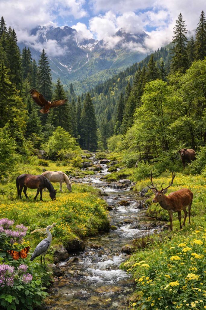
The variety of landscapes across Bulgaria supports a wide range of ecosystems, from alpine environments to forests, river valleys, and coastal wetlands. This combination of terrain and climate allows diverse plant and animal species to thrive across the country.
Biodiversity Overview
Bulgaria is considered one of the most biologically diverse countries in Europe due to the interaction of its geographic features.
- Over 40,000 plant and animal species
- Around 35% forest coverage
- Presence of alpine, continental, and Mediterranean ecosystems
Major Ecosystems
Mountain Ecosystems
- Found in the Rila Mountains, Pirin Mountains, and Rhodope Mountains
- Include alpine meadows and coniferous forests
- Support species adapted to high elevations
Forest Ecosystems
- Cover more than one-third of the country
- Include deciduous and coniferous forests
- Habitat for deer, wild boar, foxes, and other wildlife
River and Wetland Ecosystems
- Located along the Danube River and the Black Sea coast
- Important for bird migration and aquatic life
Grassland and Agricultural Areas
- Found in plains such as the Danubian and Thracian regions
- Support pollinators, birds, and small mammals
👉 These landscapes also influence traditional food systems → Bulgarian Cuisine: Complete Food Guide.
Protected Areas
Bulgaria maintains an extensive network of protected regions:
- 3 national parks
- 11 nature parks
- 10 biosphere reserves
- Natura 2000 conservation zones
These areas preserve ecosystems and protect endangered species.
Flora and Fauna
Flora
- Over 3,800 plant species
- Around 170 endemic species
Fauna
- Large mammals such as bears and wolves
- Diverse bird populations
- Significant insect biodiversity
👉 Discover more about Bulgaria’s natural environments → Biodiversity and Natural Ecosystems in Bulgaria.
Environmental Challenges
Modern environmental pressures include:
- Air pollution in urban areas
- Agricultural and industrial impacts
- Habitat fragmentation
Conservation efforts have improved conditions in many regions.
Geographic Role
Bulgaria’s biodiversity reflects the interaction between mountains, plains, rivers, and coastal zones, creating a range of habitats within a relatively small area.
👉 Bulgaria’s natural diversity is closely tied to its geography → Bulgarian Natural Wonders.
To protect these natural systems, Bulgaria has established a network of national parks and protected areas.
Bulgarian National Parks and Protected Areas
To preserve its diverse ecosystems, Bulgaria has developed an extensive network of national parks and protected areas. These regions safeguard key landscapes ranging from high mountain environments to forests, wetlands, and coastal zones.
National Parks in Bulgaria
Bulgaria has three official national parks, each representing a different type of landscape and ecosystem:
Rila National Park
- Largest national park in Bulgaria
- Includes the famous Seven Rila Lakes
- Home to alpine ecosystems and rare species
Pirin National Park
- UNESCO World Heritage Site
- Known for glacial lakes and marble peaks
- Rich in endemic plants and ancient forests
Central Balkan National Park
- Located in the Balkan Mountains
- Preserves untouched forests and wildlife
- Includes waterfalls, gorges, and high ridges
Other Protected Areas
Beyond national parks, Bulgaria includes:
- 11 nature parks
- Numerous nature reserves
- Protected forest and mountain zones
These areas allow varying levels of human activity while maintaining environmental protection.on.
Natura 2000 Network
As part of the European Union, Bulgaria participates in the Natura 2000 network:
- Covers roughly one-third of the country
- Protects habitats and endangered species
- One of the highest coverage levels in Europe
This highlights Bulgaria’s importance in European biodiversity conservation.
Types of Protected Landscapes
Protected zones in Bulgaria include:
- Coastal habitats along the Black Sea
- Mountain ecosystems (Rila, Pirin, Balkan Mountains)
- Forest environments
- River valleys and wetlands
Geographic Role
Protected areas play a key role in maintaining ecological balance across Bulgaria by preserving natural habitats and limiting environmental impact.
👉 These landscapes are central to Bulgaria’s environmental efforts → Bulgarian Environmental Conservation Efforts.
These protected landscapes also shape how visitors experience Bulgaria’s regions, from mountain environments to coastal areas.
Recommended travel gear for exploring different regions of Bulgaria
Essential Travel Gear for Exploring Bulgaria
👉 Planning to explore Bulgaria’s diverse regions? Start with the essential travel gear below to make your trip smoother and more comfortable.
| Product | Best For | Why It’s Useful | Check Price |
|---|---|---|---|
| Lightweight Hiking Backpack | All regions | Comfortable for day trips and hiking | 👉 Check Price on Amazon |
| Waterproof Hiking Boots | Mountains | Essential for Rila, Pirin, Rhodopes | 👉 Check Price on Amazon |
| Travel Adapter (EU Plug) | All travelers | Bulgaria uses EU outlets | 👉 Check Price on Amazon |
| Portable Power Bank | Travel days | Keeps devices charged on the go | 👉 Check Price on Amazon |
| Anti-Theft Travel Backpack | Cities + transport | Extra safety in urban areas | 👉 Check Price on Amazon |
Regional Travel Guide: Exploring Bulgaria by Geography
Exploring the geography of Bulgaria by region offers the clearest way to experience the country’s variation in landscape, climate, and culture. Each area presents a distinct environment—from northern plains and central mountains to southern lowlands and the Black Sea coast.
👉 Planning your trip? Start with local food and culture → Bulgarian Cuisine: Complete Food Guide.
Northern Bulgaria: Danube Region
Defined by the Danubian Plain and the Danube River, this region offers a quieter, rural setting.
- Scenic river routes and cultural heritage sites
- River towns and historic cities such as Ruse and Vidin
- Agricultural landscapes and wine regions
👉 Explore northern Bulgaria → Danube Region Travel Guide.
Central Bulgaria: Balkan Mountains
Centered around the Balkan Mountains, this region combines natural landscapes with historical landmarks.
- Small towns with preserved traditions
- Mountain trails and forested terrain
- Historic routes such as Shipka Pass
Southern Bulgaria: Thracian Plain
The southern lowlands, centered around the Thracian Plain and cities like Plovdiv, offer a mix of urban culture and agriculture.
- Warm climate supporting diverse crops
- Vineyards and farming regions
- Archaeological sites and historic centers
👉 Learn more → Bulgarian Cuisine: Complete Food Guide.
Southwestern Bulgaria: Mountain Regions
This region includes the Rila Mountains, Pirin Mountains, and Rhodope Mountains.
- Traditional villages in mountainous settings
- High mountain terrain and alpine landscapes
- Protected natural areas
Eastern Bulgaria: Black Sea Coast
Along the Black Sea, Bulgaria’s eastern region offers a coastal environment distinct from inland areas.
- Seasonal tourism and maritime landscapes
- Coastal cities such as Varna and Burgas
- Historic towns including Nessebar and Sozopol
👉 Plan your coastal trip → Black Sea Resorts: Beaches, Cities, and Coastal Culture.
Rural Bulgaria: Villages and Countryside
Across all regions, rural areas provide insight into traditional lifestyles and local culture.
- Mountain villages and countryside settlements
- Local crafts and food traditions
- Slower-paced travel experiences
👉 Explore authentic rural life → Bulgarian Villages and Rural Culture.
Travel Perspective
Viewing Bulgaria by region highlights how geography shapes travel experiences across the country. From mountains to coast, each area offers a distinct landscape and cultural setting within a relatively small territory.
Each region also supports different types of travel experiences, from mountain exploration to coastal tourism.
👉 To fully experience it, explore beyond one region and discover how geography shapes the entire country.
Eco Travel & Outdoor Living Gear
👉 For rural and eco travel experiences, these tools help you stay comfortable while respecting nature.
| Product | Best For | Why It’s Useful | Check Price |
|---|---|---|---|
| Reusable Water Bottle | Eco travel | Reduces plastic use | 👉 Check Price on Amazon |
| Solar Charger | Remote areas | Charge devices sustainably | 👉 Check Price on Amazon |
| Compact Camping Stove | Rural stays | Useful in nature settings | 👉 Check Price on Amazon |
| Travel Blanket | Countryside | Comfort during long trips | 👉 Check Price on Amazon |
| Binoculars | Nature & wildlife | Great for birdwatching | 👉 Check Price on Amazon |
Mountain Tourism in Bulgaria: Skiing, Hiking, and Adventure
Mountain tourism is a major part of travel in the geography of Bulgaria, offering year-round opportunities across ranges such as the Rila Mountains, Pirin Mountains, and Rhodope Mountains. These regions provide a mix of winter sports, summer hiking, and outdoor activities within relatively short travel distances.
Winter Tourism
During winter, Bulgaria’s mountain resorts attract visitors with consistent snow conditions and developed infrastructure.
- Bansko — largest and most developed resort
- Borovets — located in the Rila Mountains
- Pamporovo — situated in the Rhodope Mountains
Resorts offer slopes for different skill levels and are known for their affordability compared to Western Europe. prices.
Summer Tourism
In warmer months, mountain regions shift toward hiking and outdoor exploration.
- Trails such as the Seven Rila Lakes
- Routes within Pirin National Park
- Forest paths and villages in the Rhodope Mountains
Cooler temperatures at higher elevations make these areas suitable for extended outdoor activity.
Adventure Tourism
Beyond seasonal travel, Bulgaria’s mountains support a range of activities:
- Hiking and trekking
- Mountain biking
- Rock climbing and mountaineering
- Cave exploration in regions such as the Rhodopes
These activities highlight the varied terrain found across Bulgaria’s mountain regions.defined by its mountain ranges, which cover a large portion of the country and shape both climate and biodiversity.
Accessibility and Value
Mountain destinations in Bulgaria are relatively easy to reach:
- Short distances between major regions
- Well-connected transport routes
- Wide range of accommodation options
This accessibility allows visitors to combine mountain travel with other regions such as the coast or plains.
Cultural and Natural Experience
Mountain areas also preserve traditional ways of life:
- Villages with regional architecture
- Local food and agricultural practices
- Folklore and cultural traditions
👉 Outdoor lifestyles remain closely tied to local culture → Bulgarian Lifestyle and Daily Habits.
Travel Perspective
Mountain tourism reflects how geography shapes travel experiences in Bulgaria, offering seasonal variation and diverse landscapes within a compact area.
In contrast to high alpine regions, some areas offer a more cultural and traditional mountain experience.
👉 Discover more outdoor experiences → Mountain Tourism in Bulgaria.
Hiking & Mountain Gear
👉 If you’re heading into the mountains, having the right gear is essential for both safety and comfort.
| Product | Best For | Why It’s Useful | Check Price |
|---|---|---|---|
| Trekking Poles | Hiking trails | Reduces strain on steep terrain | 👉 Check Price on Amazon |
| Insulated Water Bottle | All seasons | Keeps water cold or hot | 👉 Check Price on Amazon |
| Outdoor Jacket (Lightweight) | Mountains | Weather changes quickly | 👉 Check Price on Amazon |
| GPS Hiking Watch | Adventure travelers | Navigation + tracking | 👉 Check Price on Amazon |
| Compact First Aid Kit | Safety | Essential for remote areas | 👉 Check Price on Amazon |
Rhodope Region Travel: Villages, Folklore, and Nature
Traveling through the Rhodope Mountains offers a distinct experience within the geography of Bulgaria, shaped by forested terrain, traditional villages, and long-standing cultural practices. Compared to the higher alpine regions, the Rhodopes provide a more accessible and culturally focused mountain environment.
Traditional Villages
The region is known for well-preserved mountain settlements that reflect local architecture and lifestyle.
- Shiroka Laka — traditional architecture and folklore heritage
- Yagodina — access to caves and natural landmarks
- Gela — associated with music and local traditions
Stone houses, narrow streets, and hillside layouts define the structure of these villages.
Folklore and Culture
The Rhodope region is closely linked to the legend of Orpheus, which has influenced its cultural identity.
- Traditional folk music and singing
- The kaba gaida (regional bagpipe)
- Local festivals and community events
These traditions remain part of everyday life in many areas.
Natural Landmarks
The Rhodopes include several notable природни sites:
- Trigrad Gorge — steep canyon landscape
- Devil’s Throat Cave — underground waterfall and legends
- Yagodina Cave — accessible cave system
These features reflect the geological diversity of the region.
Outdoor Activities
The terrain supports a range of low- to moderate-intensity activities:
- Hiking through forested trails
- Cave exploration
- Wildlife observation
- Nature photography
Compared to higher mountain ranges, the Rhodopes offer broader accessibility for different types of travelers.
Local Food and Lifestyle
Regional cuisine reflects the agricultural and mountain environment:
- Homemade dairy products
- Simple, locally sourced dishes
- Traditional cooking methods
👉 These traditions are part of Bulgaria’s broader cultural identity → Bulgarian Villages and Rural Culture.
Travel Perspective
The Rhodope region highlights the connection between landscape and cultural traditions, offering a quieter and more regionally distinct travel experience within Bulgaria.
Alongside mountain regions, Bulgaria’s coastal areas provide a completely different travel experience centered around the Black Sea.
If Bulgaria’s geography has a “soul,” it can be found in the Rhodope Mountains. Here, landscapes, legends, and traditions come together to create a unique travel experience that goes beyond sightseeing—it becomes a cultural journey.
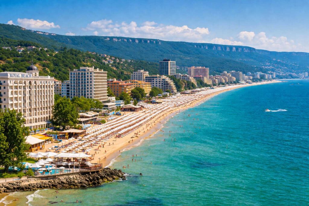
Black Sea Resorts: Beaches, Cities, and Coastal Culture
Along the Black Sea, Bulgaria’s eastern coastline transforms into a major tourism region defined by beaches, historic towns, and resort infrastructure. This coastal area offers a distinct travel experience compared to the country’s inland landscapes.
Major Coastal Cities
The main urban centers along the coast provide access to surrounding resorts and attractions:
- Varna — a major port and cultural hub
- Burgas — a southern center for tourism and transport
These cities combine urban amenities with proximity to coastal destinations.
Popular Resorts
Bulgaria’s coastline includes several well-developed resort areas:
- Sunny Beach — largest resort, known for nightlife and entertainment
- Golden Sands — combines beach access with natural surroundings
- Albena — quieter resort with a focus on family-friendly travel
These destinations offer a range of accommodation, dining, and recreational options.
Historic Coastal Towns
In contrast to modern resorts, several towns preserve the region’s historical character:
- Nessebar — UNESCO-listed town with preserved architecture
- Sozopol — one of the oldest coastal settlements in Bulgaria
These locations highlight the cultural depth of the coastline.
Coastal Landscape
The Black Sea coast features varied natural environments:
- Long sandy beaches
- Rocky cliffs and small bays
- Coastal lakes and wetlands
Calm sea conditions and minimal tides make the area suitable for swimming and water-based activities.
Cultural Environment
Coastal life reflects a mix of traditional and modern influences:
- Local seafood-based cuisine
- Seasonal festivals and events
- Blend of historic and contemporary development
👉 Coastal regions influence local food traditions → Bulgarian Seafood and Coastal Dishes.
Geographic Role
The Black Sea resorts represent Bulgaria’s connection to maritime travel and seasonal tourism, adding a coastal dimension to the country’s geography.
Beyond coastal tourism, Bulgaria also offers unique experiences in its rural and lesser-developed regions.
Rural and Eco Tourism in Bulgaria
Beyond major cities and coastal resorts, rural areas across the geography of Bulgaria offer a different type of travel experience centered on nature, traditional lifestyles, and local communities. These regions provide access to landscapes and cultural practices that remain closely tied to the environment.
Rural Tourism
Rural tourism focuses on village life and countryside environments where traditional practices are still maintained.
- Family-run guesthouses
- Traditional architecture and settlement patterns
- Locally produced food and agricultural products
- Quiet, nature-based surroundings
These areas provide a slower pace of travel compared to urban or resort destinations.
Eco Tourism
Eco tourism emphasizes responsible travel within natural environments.
- Exploration of protected areas and landscapes
- Low-impact outdoor activities
- Support for local communities and conservation efforts
Regions such as the Rila Mountains, Pirin Mountains, and Rhodope Mountains are central to these experiences.
Key Regions
Several parts of Bulgaria are known for rural and eco tourism:
- Rhodope Mountains — villages, forests, and cultural traditions
- Balkan Mountains — scenic routes and historic settlements
- Danubian Plain — agricultural landscapes and wine regions
Each region reflects a different aspect of rural life.
👉 Explore authentic countryside life → Bulgarian Villages and Rural Culture.
Activities
Common activities include:
- Hiking and nature walks
- Farm stays and local experiences
- Cultural workshops and crafts
- Wildlife observation
These activities focus on direct interaction with both landscape and local communities.
Local Food Traditions
Food in rural areas reflects regional agriculture and traditional methods:
- Fresh, locally sourced ingredients
- Homemade dairy and bread
- Seasonal produce and simple preparation
Travel Perspective
Rural and eco tourism highlight the connection between landscape and lifestyle in Bulgaria, offering a contrast to more developed tourist areas.
Together, these diverse travel experiences show how geography shapes life and movement across Bulgaria.
Travel Comfort & Organization
👉 Visiting the Black Sea coast? These essentials will help you enjoy your beach experience to the fullest.
| Product | Best For | Why It’s Useful | Check Price |
|---|---|---|---|
| Packing Cubes | Organization | Keeps luggage structured | 👉 Check Price on Amazon |
| Neck Travel Pillow | Flights & buses | Comfort on long trips | 👉 Check Price on Amazon |
| Luggage Scale | Travelers | Avoid overweight fees | 👉 Check Price on Amazon |
| Travel Wallet Organizer | Documents | Keeps passport/cards safe | 👉 Check Price on Amazon |
| Noise Cancelling Earbuds | Transport | Better travel experience | 👉 Check Price on Amazon |
👉 Before you finalize your trip, make sure you’re fully prepared with these travel essentials.
Why Bulgaria’s Geography Matters Today
The geography of Bulgaria continues to shape the country’s development, influencing its economy, environment, and regional connections. The interaction between mountains, plains, rivers, and coastline affects how industries operate and how regions evolve.
Economic and Regional Impact
Geographic variation supports different sectors across the country:
- Fertile plains enable large-scale agriculture
- Mountain and coastal regions support tourism
- The Danube River and Black Sea ports connect Bulgaria to wider trade networks
This distribution creates regional specialization and economic balance..
Tourism and Global Appeal
Bulgaria’s landscape allows for multiple types of travel within a compact area:
- Mountain regions for winter and summer activities
- Coastal areas along the Black Sea
- Rural regions preserving traditional lifestyles
This diversity supports year-round tourism.
Environmental and Resource Management
Geography also influences environmental systems and resource use:
- Forests and protected areas support biodiversity
- Rivers contribute to water supply and hydropower
- Natural landscapes require sustainable management
Ongoing conservation efforts aim to balance development with environmental protection.
Cultural and Regional Identity
Geographic differences shape how people live across Bulgaria:
- Settlements are closely linked to terrain
- Regional traditions vary by landscape and climate
- Food production reflects local environments
👉 Geography continues to influence broader contributions → Bulgarian Contributions to Modern Technology.
Strategic Location in Europe
Bulgaria’s location in Southeastern Europe adds to its geographic significance:
- Connected through land and maritime routes
- Positioned between European and neighboring regional markets
- Part of key transport and trade corridors
Final Perspective
The geography of Bulgaria remains a defining factor in how the country functions today. Its landscapes influence economic activity, environmental systems, and cultural patterns, while also shaping future development. Understanding this geography provides insight into both the country’s current structure and its long-term potential.
FAQs About the Geography of Bulgaria
What is the geography of Bulgaria known for?
The geography of Bulgaria is known for its remarkable diversity, including high mountain ranges, fertile plains, major river valleys, and a Black Sea coastline. Despite its relatively small size, Bulgaria contains a wide variety of landscapes that shape its climate, agriculture, biodiversity, and tourism.
Where is Bulgaria located geographically?
Bulgaria is located in Southeastern Europe on the Balkan Peninsula. It borders Romania to the north, Serbia and North Macedonia to the west, Greece and Turkey to the south, and the Black Sea to the east.
What are the main landforms in Bulgaria?
The main landforms in Bulgaria are the Danubian Plain, the Balkan Mountains, the Thracian Plain, and the Rila-Rhodope mountain massif. These regions create a mix of lowlands, valleys, plateaus, and alpine terrain across the country.
What is the highest mountain in Bulgaria?
The highest mountain peak in Bulgaria is Musala, located in the Rila Mountains. It rises to 2,925 meters (9,596 feet), making it the highest point in both Bulgaria and the entire Balkan Peninsula.
What mountain ranges are in Bulgaria?
Bulgaria’s major mountain ranges include the Balkan Mountains, Rila Mountains, Pirin Mountains, and Rhodope Mountains. Other important ranges include Vitosha, Osogovo, Belasitsa, and Sredna Gora.
Does Bulgaria have a coastline?
Yes, Bulgaria has a coastline along the Black Sea. The coast stretches for about 354 kilometers and includes beaches, cliffs, bays, wetlands, and major resort areas such as Sunny Beach, Golden Sands, Varna, and Burgas.
What are the major rivers in Bulgaria?
The major rivers in Bulgaria include the Danube, Iskar, Maritsa, and Struma. The Danube forms much of Bulgaria’s northern border, while the Iskar is the longest river located entirely within Bulgarian territory.
Why is the geography of Bulgaria important?
The geography of Bulgaria is important because it influences climate, biodiversity, agriculture, and tourism.
What climate does Bulgaria have?
Bulgaria has a varied climate influenced by continental, Mediterranean, and mountain conditions. Northern Bulgaria tends to have colder winters and hotter summers, southern Bulgaria has more Mediterranean influence, and mountainous areas experience cooler temperatures and more snowfall.
Why is the Balkan Mountains range important in Bulgaria?
The Balkan Mountains are important because they divide Bulgaria into northern and southern parts and strongly influence the country’s climate, history, and settlement patterns. They also gave the Balkan Peninsula its name.
What is the Thracian Plain in Bulgaria?
The Thracian Plain is a fertile lowland region in southern Bulgaria. It is one of the country’s most productive agricultural areas and is especially important for grain, fruit, vegetable, and vineyard cultivation.
What is the Danubian Plain in Bulgaria?
The Danubian Plain is a broad region in northern Bulgaria that stretches south of the Danube River.
Is Bulgaria mountainous?
Yes, Bulgaria is considered a highly mountainous country, especially in its western, southwestern, and southern regions. Mountains and hills cover a large part of the territory, while plains occupy about one-third of the land.
What makes the Rhodope Mountains special?
The Rhodope Mountains are special for their natural beauty, folklore, traditional villages, forests, caves, and strong connection to Bulgarian culture and legends. They are often seen as one of the most atmospheric and culturally rich regions in the country.
Is Bulgaria good for hiking and nature tourism?
Yes, Bulgaria is excellent for hiking and nature tourism. The country offers national parks, alpine lakes, forest trails, dramatic gorges, ski resorts, and scenic mountain villages, making it ideal for outdoor travel in every season.
How does geography affect life in Bulgaria?
Geography affects life in Bulgaria by shaping regional traditions, food production, travel patterns, climate, local economies, and settlement history. Mountains, plains, rivers, and the Black Sea all influence how different parts of the country developed over time.
Why is Bulgaria considered geographically diverse?
Bulgaria is considered geographically diverse because it includes multiple climate zones and landforms within a compact area. Few countries of similar size have such a strong mix of mountains, plains, river systems, forests, and coastline.
What are the best natural regions to visit in Bulgaria?
Some of the best natural regions to visit in Bulgaria include the Rila Mountains, Pirin Mountains, Rhodope Mountains, the Black Sea coast, the Danube region, and the Thracian Plain. Each offers a different travel experience, from hiking and skiing to beaches and cultural tourism.
Bulgaria Travel Guide by Geography
Bulgaria offers a diverse travel experience shaped by its geography—from mountains and plains to coastal regions. This Bulgaria travel guide helps you explore the country based on landscape, climate, and regional highlights.
What makes the geography of Bulgaria unique?
Bulgaria combines mountains, plains, rivers, and coastal regions within a compact area, allowing for diverse landscapes and climates.
What are the main geographic regions of Bulgaria?
The main geographic regions of Bulgaria include the Danubian Plain, Balkan Mountains, Thracian Plain, Rila–Rhodope Massif, and the Black Sea coast.
Conclusion: A Country Shaped by Its Landscape
The geography of Bulgaria forms the foundation of the country’s identity, shaping its history, culture, and modern development. Within a relatively small territory, Bulgaria brings together mountain ranges such as the Rila Mountains and Pirin Mountains, fertile plains like the Danubian and Thracian regions, major waterways including the Danube River, and a coastline along the Black Sea.
This combination of landscapes supports a wide range of activities and traditions—from agriculture and regional food production to mountain and coastal travel experiences. The interaction between these environments creates a level of geographic variety that is uncommon within such a compact area.
Looking ahead, the geography of Bulgaria continues to influence the country’s direction. Natural resources, environmental systems, and regional diversity all play a role in economic development, sustainability, and international connectivity. Understanding this geography provides a clearer view of how Bulgaria functions today and how it may evolve in the future.
👉 Whether you are studying it, visiting it, or building content around it, one thing is clear: to understand Bulgaria, you must understand its geography.
References
- Wikipedia. Geography of Bulgaria. https://en.wikipedia.org/wiki/Geography_of_Bulgaria
- CIA World Factbook. Bulgaria. https://www.cia.gov/the-world-factbook/countries/bulgaria/
- World Bank. Bulgaria Country Overview. https://www.worldbank.org/en/country/bulgaria
- European Environment Agency. Biodiversity in Bulgaria. https://www.eea.europa.eu
- UNESCO. World Heritage Sites in Bulgaria. https://whc.unesco.org/en/statesparties/bg
- Bulgarian Ministry of Tourism. Official Travel Guide. https://bulgariatravel.org
- National Institute of Meteorology and Hydrology. Climate Data of Bulgaria. https://www.meteo.bg
- Food and Agriculture Organization (FAO). Land Use and Agriculture in Bulgaria. https://www.fao.org
- Eurostat. Environmental and Geographic Data: Bulgaria. https://ec.europa.eu/eurostat
- World Wildlife Fund (WWF). Biodiversity and Ecosystems in Bulgaria. https://www.worldwildlife.org
- Bulgarian Academy of Sciences. Geography and Natural Resources Research. https://www.bas.bg
- Natura 2000 Network. Protected Areas in Bulgaria. https://natura2000.eea.europa.eu
- National Statistical Institute of Bulgaria. Geographical and Environmental Statistics. https://www.nsi.bg
- European Commission. Environment and Climate Reports on Bulgaria. https://ec.europa.eu
- Encyclopaedia Britannica. Bulgaria. https://www.britannica.com/place/Bulgaria